Saugeen River Canoe Route
Brant Concession 8 to Brant Concession 10
(paddle time 2hrs)
As the Saugeen progresses toward Lake Huron, the woodlands and bluffs of the upper areas give way to the rolling farmland of the middle sections. It is common to see cattle, horses and other livestock coming down to the river for a drink. The river slowly meanders through this mixed agricultural and forested land, this mixed habitat is ideal for the deer populations in the area and therefore sittings are common. A set of power-lines crosses the river in this section. These mark the halfway point of the Hanover-Southampton portion of the Saugeen River.
River Access
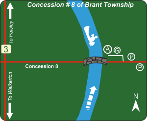
Concession #8 of Brant Township
Location: Concession #8 is .2km west of Sideroad #10 or 2.5 km east of Bruce Road #3.
Directions: Traveling north on Hwy# 9, take County Road #3 (Elora Road) turnoff just past the town of Mildmay. Follow County Road #3 past Hwy #9 and the turn off to Walkerton; about 7km beyond Hwy #9 is Brant Concession #8. Watch for the small County Road sign on the corner and turn right. Follow road for 2.5km until you reach the bridge.
Facilities: River access, parking, garbage cans.
Description: 80m to river access, be careful on 3m high bank on northeast side of bridge. Parking in lane blocks flow of traffic. Roadside parking is on the east side of the bridge.